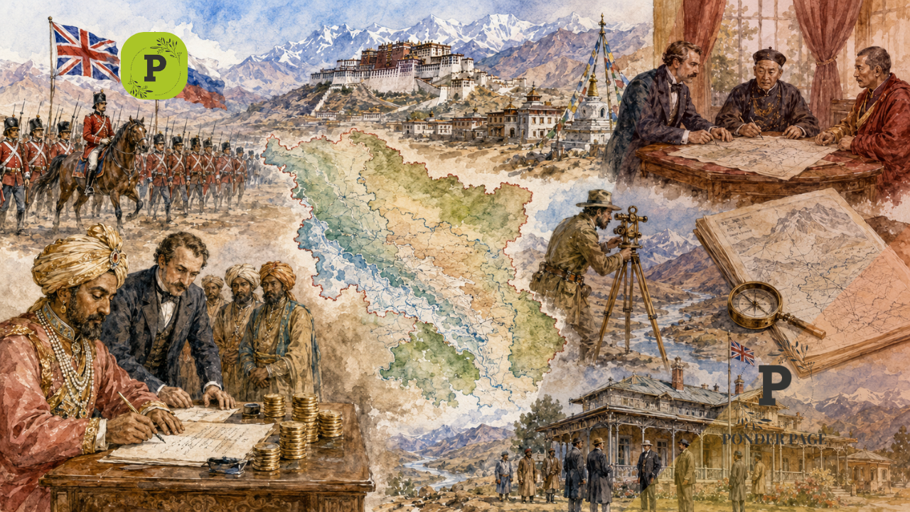
From The Great Game to McMahon Line: The year 1845 marked a crucial phase in the history of the Indian subcontinent, a time when the The Great Game was unfolding between the British Empire and Russia. This strategic rivalry was not merely about territorial expansion but about influence across Central and South Asia. The British, who ruled India at the time, were deeply concerned about Russia’s expansionist ambitions. There was a growing fear that Russia might extend its influence into Tibet and the territories controlled by the Sikh-Dogra Empire, thereby threatening British interests in India.
To counter this perceived threat, the British identified the northern frontiers, particularly the Ladakh region, as strategically vital. Securing this area became a priority to prevent any possible Russian incursion.
(You can now subscribe to our Ponder Page WhatsApp channel)

Table of Contents
British Expansion and the Rise of Gulab Singh
On 11 December 1845, the British launched an attack on the Sikh Empire, consolidating their control over the region through a series of agreements that heavily favored them. This marked the beginning of strong British influence in the northern territories.
Around the same time, Gulab Singh emerged as a key figure. He paid ₹75 lakh to the British and acquired Kashmir, subsequently becoming its ruler. For the British, this arrangement was convenient. Their primary concern lay in securing Ladakh and preventing Russian access through areas like Aksai Chin, rather than directly administering Kashmir.
Securing the Frontier: Survey and the Johnson Line
Despite establishing influence, the British soon realized that regions like Aksai Chin still posed vulnerabilities. There were multiple routes through which Russian forces could potentially enter. To address this, in 1855, the British assigned the Great Trigonometrical Survey of India the task of surveying the Ladakh-Tibet region and defining clear boundaries.
This responsibility was given to W. H. Johnson, who conducted extensive surveys and proposed a boundary known as the Johnson Line. This line placed Aksai Chin within the boundaries of British India and forms the basis of India’s current territorial claim in that region.
The British unilaterally defined this boundary, incorporating key strategic points within their control, and communicated it to China and Tibet. China’s response at the time suggested that the region already had traditional boundaries and did not require redefinition.
Eastern Boundaries and the 1890 Convention
While the western frontier saw active boundary-making, the eastern sector, particularly around Sikkim, also required attention. There were several undefined areas that could potentially allow foreign entry.
To address this, on 17 March 1890, the British held a convention with China, resulting in the formal demarcation of the boundary from the Gamochen mountain to Nepal. This agreement brought clarity to the Sikkim region and was accepted by China.

The Three Sectors of the India-China Boundary
The India-China boundary can broadly be divided into three sectors: the western sector (Aksai Chin), the middle sector, and the eastern sector (including Sikkim and Arunachal Pradesh).
In the western sector, the British had proposed the Johnson Line, which China did not accept. The middle sector, characterized by difficult mountainous terrain, naturally formed a boundary and witnessed relatively fewer disputes. The eastern sector saw clearer demarcation in Sikkim, while the Arunachal Pradesh boundary remained to be defined.
The Macartney-MacDonald Line: A Strategic Compromise
China’s dissatisfaction with the Johnson Line posed a diplomatic challenge. Although weak at the time, China hinted at aligning with Russia, which concerned the British.
In response, in 1899, the British proposed a revised boundary known as the Macartney-MacDonald Line. This new line retained key strategic areas for the British but ceded a significant portion of Aksai Chin to China. Interestingly, the present-day Line of Actual Control (LAC) roughly aligns with this proposed boundary, though with some variations.
China, however, did not formally respond to this proposal either. British maps over time showed inconsistency, sometimes reflecting this revised line and sometimes not.
The Shimla Convention of 1914 and the McMahon Line
By the early 20th century, the British sought a more stable solution to their northern frontier concerns. In 1914, they convened a meeting in Shimla involving representatives from Britain, China, and Tibet. This resulted in the Shimla Convention.
The British proposed dividing Tibet into Inner Tibet, which would remain under Chinese control, and Outer Tibet, which would function as a buffer zone under the leadership of the Dalai Lama. This buffer was intended to separate British India from direct Chinese influence.
During this convention, Henry McMahon introduced the McMahon Line, which defined the boundary between Tibet and what is now Arunachal Pradesh.
While Tibet accepted the agreement, China refused to sign it, rejecting the division of Tibet and asserting full control over the region.
Conflicting Claims and Lasting Implications
Despite China’s refusal, the British treated the agreement as valid, arguing that Tibet had the authority to decide its boundaries. Consequently, official British maps consistently showed Aksai Chin as part of India.
Interestingly, even China did not initially depict Aksai Chin within its official maps. This observation is noted by Ramachandra Guha in his book India After Gandhi.


From The Great Game to McMahon Line: Foundations of a Modern Dispute
The boundary-making efforts of the British during the 19th and early 20th centuries were driven by strategic considerations rather than mutual agreements. Lines such as the Johnson Line, Macartney-MacDonald Line, and McMahon Line were drawn in response to geopolitical pressures, often without consensus from all parties involved.
These historical decisions laid the groundwork for the complex and ongoing boundary disputes between India and China. What began as imperial strategy during the Great Game continues to shape modern geopolitics in the region today.
What are your thoughts on this article? Let us know in the comments below. If you enjoyed this article, be sure to subscribe for more engaging content in the future! Stay updated on the latest developments and discussions by clicking the subscribe button above. Thank you for your support!
📢 Dive into the latest discussions on social & trending topics! 🌍💬 Subscribe to Ponder Page for thought-provoking articles and interviews that dissect current issues. Don’t miss out on insightful content—hit that like & subscribe button now!


Leave a Reply